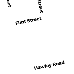
68 HAWLEY RD
Owner Information
SMITH, SAMANTHA
68 HAWLEY RD
MELROSE, MA 02176


Property Details
68 HAWLEY RD is classified as a Single Family Residential (Cape).
The primary structure on this property was built in 1953. There are 2,096ft2 of built area within this property. There is 1,152ft2 of residential/living space within this property. This property is listed as having 5 rooms.
68 HAWLEY RD is valued at $378,100. The land is valued at $210,000 and the structures are valued at $168,100.
This property is in Zone URA. Confirm with local Zoning Board authorities to ensure there are no overlays or other easements on this property.
The most recent deed for 68 HAWLEY RD is recorded at the local registrar in Book 67550, Page 205. 68 HAWLEY RD was last sold on Friday, July 1, 2016 for $420,000.
Assessment data from fiscal year 2022.
Flood Data
This property is partially within the A Zone (within floodplain). Approximately 0.02 acres (37.27%) of the property is within this zone.
This information is sourced from the FEMA National Flood Hazard Layer. See our full disclamer.
Broadband Internet Providers
| Provider | Type | Bandwidth (mbps) | |
|---|---|---|---|
| RCN | Cable | 500 | 20 |
| Verizon New England Inc. | Fiber | 940 | 880 |
| Comcast | Cable | 1000 | 35 |
| Crown Castle Fiber | Fiber | 0 | 0 |
| Viasat Inc | Satellite | 100 | 3 |
| VSAT Systems, LLC. | Satellite | 2 | 1 |
| HughesNet | Satellite | 25 | 3 |
| GCI Communication Corp. | Satellite | 0 | 0 |
| T-Mobile | Fixed Wireless | 25 | 3 |
Broadband service provider data from December 2020.